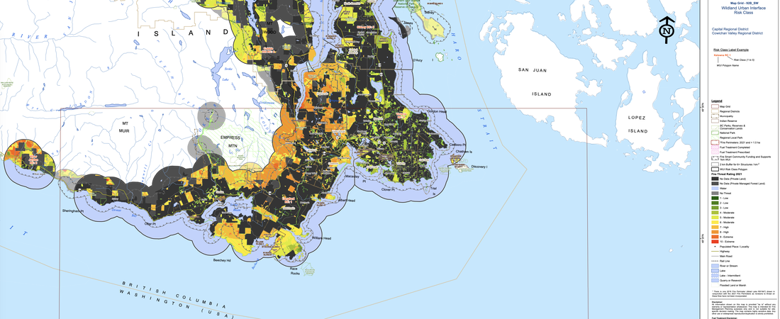
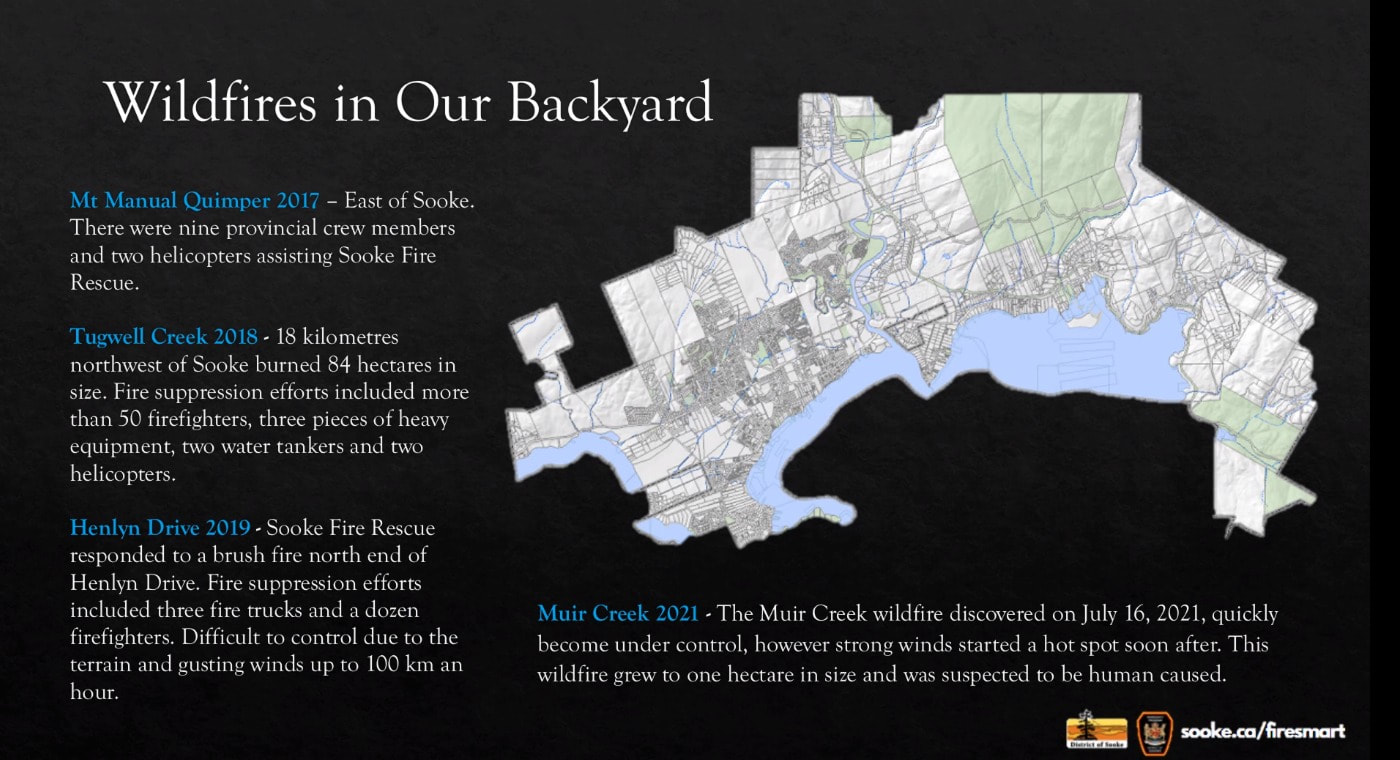
This became BC's worst-ever wildfire season on record on July 18, and it has only grown considerably worse in the weeks since. (See Aug. 17 Provincial Wildfire Status Update.) We have, touch wood, had just one small out-of-control fire in the area (Tugwell Creek, Aug. 1-3) this summer. Nonetheless, the BC Wildfire Service rates parts of Sooke in the more dangerous of its Wildland Urban Interface Risk categories, so 24/7 vigilance is essential. (A brush fire on Henlyn Road caused by a discarded cigarette butt in June, 2019 is one recent example of a near-miss; strong winds at the time threatened to make it a major event but Sooke firefighters controlled it after a long day.)
Aside from the haze on Saturday, we've not been subject to the smokey, particulate-infused days that have characterized some recent years here on the coast, i.e., August 2018, when the region's air qualified as the world's worst when it is usually - surely - among the wind-freshened best most of the time. Count us fortunate.
The District of Sooke updated its definitive emergency planning pages earlier this week, so i suggest you begin or further your own readiness planning/thinking there. More links follow here on wildfires, tsunamis, earthquakes and other potential apocalypses -- for which the province has prepared case-specific plans. [The inevitable big quake is the one that keeps me hot-eyed and sleepless occasionally when I ponder it. Reading Gregor Craigie's On Borrowed Time: North America's Next Big Quake and/or Jerry Thompson's Cascadia's Fault: The Coming Earthquake and Tsuanami that Could Devastate North America will make you a nervous believer and proactive preparer, too.]
Starting Points for Personal and Community Safety
- District of Sooke Emergency Planning
- Emergency Planning and Evacuation Considerations
<clip> "When it comes to community-wide emergencies, such as a threat of wildfire, we have an excellent team of professional and volunteer emergency responders through the District's emergency program. However, it is the combined effort of all in the community that will ensure resiliency and see our community through such an emergency."
What we residents can do ...
1. Read the extensive material in the links shared above. [Fact: Professionals in multiple public safety services have our backs and are ready for every eventuality while also counting on each of us to have our acts together.]
2. Register for automated emergency alert notifications (via phone, text or email) + EmergencyInfo BC
3. Be prepared! with grab-and-go kits and by FireSmarting your property
4. Consider volunteering with ...
- Sooke Fire Rescue Paid-On Call Recruitment
- Sooke Emergency Support Services
- Royal Canadian Marine Search & Rescue Services (Sooke Station 37)
- Juan de Fuca Search & Rescue
- Block Watch (via RCMP's Sam Haldane, email)
5. Organize a minimum of six neighbours to form a POD through the Neighbourhood Emergency Preparedness Program (NEPP). These groups plan, prepare for and share resources during emergencies.
6. Familiarize yourself with the common-sense and logical neighbourhood disaster escape-route guides contained in this agenda package (pp. 9 to 202). They're part of a grant-funded 2020 report produced by Smart Risk Control Planning Services, which worked in collaboration with Sooke Emergency Program/Sooke Fire/Rescue staff and Juan de Fuca mutual aid partners.
Sooke Emergency Planning
As you'll read in the District's links, the Province of BC's British Columbia Emergency Response Management System (BCERMS) is "a comprehensive framework that provides a structure for a standardized approach to developing, coordinating and implementing emergency management programs across the province." It provides guidance on the development of local plans, in Sooke's case these being:
- Sooke Wildfire Protection Plan, published in 2011 and now undergoing an update by its same authors, Bruce Blackwell and Associates, widely recognized among BC's top authorities on wildfire protection.
~ Sooke Emergency Response and Business Continuity Plan (2014)
The priorities of these plans:
- Provide for the safety and health of all responders;
- Save lives;
- Reduce suffering;
- Protect public health;
- Protect property and government infrastructure;
- Protect the environment;
- Reduce economic and social losses;
- Restore corporate and development services.
Ground zero for any response to a local emergency will be Sooke's Emergency Operations Centre on the second floor of Fire Hall #1. Its guidelines are detailed in the EOC Manual.
Potential emergency centres if required in the District:
- Sooke Community Hall
- Edward Milne Community School
- Metchosin Community Hall
Emergency Management BC "provides executive coordination, strategic planning and multi-agency facilitation"
- Sooke RCMP
- Fire Services
- BC Ambulance
- Emergency Social Services
- Engineering and public works contractors
- BC Housing
- JDF Search & Rescue
- Royal Canadian Marine Search & Rescue
- Harbour Authority - Sooke Government Wharf
- Neighbourhood Watch & Citizens on Patrol programs
- BC Ministry of Health
- BC Coroners' Service
Miscellaneous other links ...
Federal
~ Public Safety Canada + Wildfire Response
~ Emergency Management Strategy for Canada: Toward a Resilient 2030
~ Hazards and Emergencies
Provincial
~ Emergency Management in BC
~ All Hazard Plan (2022)
~ BC Wildfire Service
~ Legislation
~ Emergency Education Programs and Toolkits
~ Modernizing the Emergency Program Act + Latest Update (July 4, 2023)
Regional
~ Prepare Yourself! A Guide to Emergency Preparedness in the Capital Region
~ CRD Regional Emergency Management (tsunami, earthquakes, wildfires, severe weather, flooding and storm surges, landslides, infectious disease, HAZMAT incidents)
~ Public Alert Notification System (PANS) - sign up for direct notification of tsunami, wildfire or evacuation notice
~ "Greater Victoria's Water Supply Supply Deemed Highly Vulnerable to the Threat of Wildfire" - Water Canada, 2016
Sooke Region
"The Sooke Emergency Program is considered the responsible emergency management organization by the municipality. It is responsible for the planning, mitigation, response and recovery from any emergency or disaster that happens within its jurisdiction. The volunteer Emergency Support Services (ESS) group (25 members), hosts Open Houses throughout the year to educate the public on emergency preparedness and participates in the Great BC Shakeout (third Thursday each October) at all Sooke elementary schools. The Sooke Emergency Radio Group (SERG) members provide amateur emergency radio communications during an emergency." - District of Sooke Annual Report
~ Sooke Fire Rescue Department
~ Sooke Fire and Emergency Program Facebook page + Twitter
~ Sooke Emergency Operations Centre (District staff and community volunteers are trained to assist emergency professionals in the EOC command structure)
~ EOC staff working with T'Sou-ke First Nation on shared guidance and support
~ EOC at Level One readiness throughout COVID pandemic
~ Sooke Emergency Support Services (250 642-5422)
"Community Engagement team offers free emergency preparedness sessions to community groups, families, businesses, stratas, etc. to build a resilient community"
~ Sooke has tapped the UBCM's Community Emergency Preparedness Fund repeatedly in recent years for evacuation route planning, new equipment and modernization of the Emergency Operations Centre.
~ UBCM funding stream updates
Wildfires
~ BC Wildfire Service + Wildfire Map
~ FireSmoke Canada - 48-hour smoke forecasts
~ Canadian Wildland Fire Information System (daily updated national fire mapping)
~ Wildfire Glossary of Terms
~ FireSmart program prioritized as BC prepares to deal with potential local impacts of the "fifth season."
~ FireSmart Canada
~ FireSmart Begins At Home (PDF guides to home prep, landscaping and home development)
2022 BC Wildfire Season Summary (includes annual data from 2003 onwards)
"As our Sooke team moves into the new year, we are reflecting on our most recent wildfire season. The Coast had a total of 281 wildfires and was right behind the Kamloops Fire Centre in total hectares burned at 21,779. With sustained warm and dry weather throughout the fall, the season got extended well into September and October. New records were set for the months of August and October for the number of fires detected per week compared to the past 20 years."
~ "Sooke Fire Rescue Gears Up For Wildfire Season" - Sooke News Mirror, May 2020
~ Few Sooke fires annually but always possible: Sooke is now recognized as a Level 1 wildfire hazard zone given our proximity to so much (tinder dry in the summer) forested land in what's termed a "Wildland Urban Interface Zone." Blackwell & Associates studied the historical wildfire data in Sooke from 1919 onwards (pg. 12/13); we average just one or two fires in most years, almost all human caused, with 1952 (7 fires), 1973 (6) and 1978 (6) as our worst in numbers per year. The vast majority are relatively small (under a few hectares), with the record burns being a 900-hectare fire in 1922 and a 1500-hectare fire in 1927.
~ Training Exercise: Wildland Fire at Erinan Estates (2018; full-scale exercise involving multiple fire departments, the RCMP and the evacuation of 117 residents to a reception centre at EMCS)
~ Tree Canada: Wildfire and the Urban/Rural Interface
~ State of California Wildfire Preparation Tips
~ Canadian Red Cross: Wildfires - Before, During & After
~ Fuel load:
- Wildfire Science - Government of Northwest Territories
- "Western Red Cedar in a Death Spiral?" - Van Isle News, July, 2021
- "Dry Summers Take Heavy Toll on Island Trees" - Times Colonist, Sept. 2019
Earthquake
~ Province of BC: Get Prepared for an Earthquake
~ Shake-Out BC (Oct. 19 at 10:19 AM annually)
~ Provincial Earthquake Immediate Response Strategy (2022)
~ BC Earthquake Preparedness Consultation (2014)
Tsunami/Sea-Level Rise
~ BC Tsunami Zones + Capital Region map including Sooke + Alerts
~ Capital Region Tsunami Information Portal
~ CRD Seawater rise and inundation mapping
~ Sooke Tsunami Awareness
~ Staff training via Royal Roads University MA In Disaster and Emergency Management program
~ Sooke Floodplain Regulation Bylaw (adopted 2020)
~ Tsunami Community Awareness Report: Kaltasin/Sooke (RRU study)
~ "Tsunami Warning: How Well Did We Respond?" (Times Colonist, Jan. 23, 2018)
Oil Spills
~ Sooke liaison with Western Canada Marine Response Corp. and the Canadian Coast Guard
~ Inside WCMRC (Capital Daily, May 22, 2023)
~ Beecher Bay response station: "The Beecher Bay satellite base is located on Sc’ianew First Nation territory and reports to Vancouver Island operations in Nanaimo. It houses personnel, a skimming vessel, a coastal response vessel, landing craft and workboats. A warehouse and office will be complete in 2024."
Air Quality
~ Sooke Burning Bylaw 292 (revised June, 2021) + staff report
~ BC Venting Index
~ Burning Issue (from this blog)
Mutual Aid
~ CRD Fire Services: Juan De Fuca
~ Otter Point Fire Department
~ Rotary Club of Sooke donates Disaster Aid Canada kits to the Sooke Emergency Program
~ Black Press "Be Ready" Emergency Guide
~ CRD Emergency Preparedness for Pets guide
~ CRD Seasonal Readiness Planning sessions each spring
Other Province of BC Emergency Plans
- Provincial Flood Emergency Plan
- Flood Waste and Debris Removal Plan
- Pandemic Provincial Coordination Plan
- Tsunami Notification Process Plan
- Provincial Coordination Plan for Wildland Urban Interface Fires
- Extreme heat preparedness for agencies and ministries
- Nuclear Emergency Plan for B.C.
- Agriculture Emergency Planning
- B.C. Coroners Service Mass Fatality Response Plan
- B.C. Drought Response Plan
- B.C. Public Post-Secondary Education Sector Integrated Response Plan for Catastrophic Events
- Dam Safety Program
- Disaster Response Routes
- Emergency Management Planning Guide for Schools, Districts and Authorities
- Federal Emergency Response Plan
- Foreign Animal Disease Emergency Support Plan for B.C.
- Spills and Environmental Emergencies
Recent News Articles
~ "Canada's Ability to Prevent Forest Fires Lags Behind the Need" ~ New York Times, June 9, 2023
~ "How To Break Western Canada's Accelerating Cycle of Wildfires" - Globe & Mail, June, 2019
Footnote: A member of the public came to Sooke council last month and stated that human stupidity is the cause of wildfires, not climate change, reducing a complex matter to an either/or statement. I asked Sooke's Fire Chief about this later in the meeting, and he gave a more nuanced answer.
Yes, he said, natural causes (lightning strikes responsible for 60% of wildfires) and braindead human behaviour (40%) -- i.e., cigarette butt-tossers, campers who don't extinguish the campfires they shouldn't have started in the first place, outright arson -- remain the leading factors in what a month ago was already the record wildfire season in BC.
And yet he also noted that fuel load in our forests and clearcuts has increased dramatically due to the extended droughts that have become routine in recent years.
Sooke's Wildfire Protection Plan (2011) addresses "Future Climate Considerations" on pp. 8/9. "Implications for wildfire are that drought events could result in extended wildfire seasons with more days of fire weather supporting difficult to control wildfires (i.e., more high and extreme danger class days than shown in Figure 5) and drought conditions supporting more severe fire effects (i.e., more high and extreme drought code days than shown in Figure 4). Severe wildfires occurring under drought conditions may consume more of the duff layers and heat the mineral soil, leaving those soils more prone to erosion. Extreme rainfall events that occur before those soils have been re-colonised by vegetation would likely result in substantial erosion."
~ Defining "Fire Weather" (National Resources Canada). "Fire weather refers to weather conditions that are conducive to wildland fire, affecting its occurrence and subsequent behaviour. It determines the fire season – the annual period during which forest fires are likely to start, spread, and cause damage. Changes in fire weather affect forest ecosystems, as well as human health and safety and the ability to access the forest.Preliminary analyses show that the fire season has become longer in some regions of eastern Canada and shorter in most of southwestern Canada. Future projections suggest that the fire season will lengthen in almost all areas. By 2100, the fire season in certain forest regions may have lengthened by more than a month."
~ "Warming Sets the Stage for Canada's Record Wildfires, Study Finds" - New York Times, Aug. 22, 2023.
<clip> "Hot, dry and gusty conditions like those that fed this year’s wildfires in eastern Canada are now at least twice as likely to occur there as they would be in a world that humans hadn’t warmed by burning fossil fuels, a team of researchers said Tuesday, providing a first scientific assessment of climate change’s role in intensifying the country’s fires ... “Fire-weather risks due to climate change are increasing,” said Dorothy Heinrich, a technical adviser at the Red Cross Red Crescent Climate Center who worked on the analysis. “Both mitigation and dedicated adaptation strategies are going to be required to reduce the drivers of risk and decrease its impacts on people’s lives, livelihoods and communities.”
~ Climate Atlas of Canada: Forest Fires and Climate Change (2023) <clip> "To figure out what climate change means for forest fires in Canada, Flannigan and a team of researchers at the Canadian Forest Service analyzed the findings of almost 50 international studies on climate change and fire risk. [4] They found that our future looks “smoky” because climate change will worsen the three major factors that influence wildfire: having dry fuel to burn, frequent lightning strikes that start fires, and dry, windy weather that fans the flames ... Another recent study [5] by Flannigan and several other scientists predicts that western Canada will see a 50% increase in the number of dry, windy days that let fires start and spread, whereas eastern Canada will see an even more dramatic 200% to 300% increase in this kind of “fire weather.” Other studies predict that fires could burn twice as much average area per year in Canada by the end of the century as has burned in the recent past. [6]"
~ "There Are Complex Reasons for Our Dire Wildfires, But Scientists Say Climate Change Plays a Key Role" - CBC British Columbia, Aug. 19, 2023.
~ Fire Weather: The Making Of A Beast - John Vaillant (McNally Robinson Books, 2023). "In May 2016, Fort McMurray, the hub of Canada's petroleum industry and America's biggest foreign supplier, was overrun by wildfire. The multi-billion-dollar disaster melted vehicles, turned entire neighborhoods into firebombs, and drove 88,000 people from their homes in a single afternoon. Through the lens of this apocalyptic conflagration--the wildfire equivalent of Hurricane Katrina--John Vaillant warns that this was not a unique event but a shocking preview of what we must prepare for in a hotter, more flammable world."
~ The Fire Beast Is Everywhere: A Checklist for Fighting Back - Guy Dauncey. "In a few short decades, we have burned our way through fossilized energy that took millions of years to form. We have released all of its stored carbon into the atmosphere, where, as carbon dioxide, it traps heat. As a New Scientist editorial stated in June 2023, “The basic science of climate change is so universally accepted that only the most fringe elements of society now deny it.”
- What Lies Beneath: Exploring Canada's Invisible Carbon Storehouse - Globe & Mail, Nov. 10, 2021
- World Wildlife Federation: Canadian Carbon Map (2022). "Canada’s first-ever national carbon map reveals the location of billions — yes, billions — of tonnes of carbon stored in ecosystems across the country. This data, and how we use it, could alter the pace of climate change." + Final report
Image: The BC Wildfire Service's Wildland Urban Interface Risk Class Map identifies local red danger zones (i.e., extreme risk) in the hills north of Saseenos, T'Sou-ke Reserve #2 and the Phillips Road/Sunriver corridor. Yellow and orange areas (moderate/high risk) cover a large swath of the Sooke Hills. Much of our area map is black, indicating private and managed forestry land that hasn't been assessed.


 RSS Feed